

Island Resiliency
Protecting Crystal River’s Natural Barriers
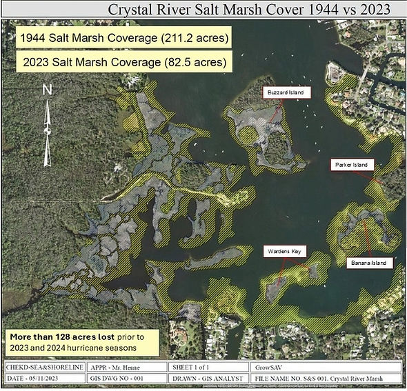
Crystal River’s inland barrier islands and salt marshes form a natural shield that protects homes, businesses, and critical infrastructure in Kings Bay from storm surge, wave energy, and sea level rise. Since 1944, more than 125 acres of these inland barrier islands and surrounding marshes have been depleted by storm and wave action, sea level rise, and other environmental factors.
Without these islands, there is little protection for the residential and commercial structures along the eastern and southern shorelines of Kings Bay. Rebuilding these islands now will restore protective terrain and provide added protection for important springs such as King Spring and for the broader community.
Where has this worked before?
The use of WADS in similar situations has been successfully used for shoreline restoration at Apollo Beach, the Sunshine Skyway Bridge, and many other shoreline restoration locations throughout Florida.
What's at Risk

Aerial View of Parker Island.
Northern red area is the channel that is occluded.
Left side of the island is the area that will be restored using hybrid reefs, sea grass, and marsh grass.
Only four islands, Banana Island, Parker Island, Buzzard Island, and Warden Key, currently form the protective barrier between storm surges and the homes and businesses on the eastern and southern shores of Kings Bay. These islands are also critical habitat for breeding and nesting birds, fish, and manatees, and they form the core of the designated manatee refuge in Kings Bay.
As a result of repeated storm events, sea level rise, and increased commercial and recreational boating activity, these islands and their surrounding salt marshes have decreased in size by more than 125 acres. A geospatial erosion analysis over a 3.3 km² area of Kings Bay, using aerial imagery from 2010 to 2021, found:
-
Average annual erosion of about 3.1 acres, with some shoreline segments eroding nearly 10 feet per year
-
Net annual area loss of about 2.8 acres
-
Total documented loss of 7.2 acres from 2010 to 2025, roughly equal to 5.5 football fields
Island-specific losses over the 2010–2025 period include:
-
Banana Island: up to 10 feet of shoreline retreat per year and about 40 percent loss of its area
-
Warden Key: more than one-third of its area lost
-
Parker and Buzzard Islands: measurable shoreline retreat and ongoing area loss
Most erosion occurs along natural, unprotected shorelines and island edges. This land loss not only reduces storm protection, it also accelerates sediment movement into nearby spring vents, which can reduce spring flow and smother recovering eelgrass beds.
How We Rebuild Shorelines

Save Crystal River and its partners are advancing a Marsh and Shoreline Resiliency Protection Project that combines shoreline engineering with marsh and seagrass restoration. Parker Island, a 5.5-acre island on the southeast side of Kings Bay that surrounds a natural spring and is a popular destination for fishermen, boaters, swimmers, and paddlers, serves as the pilot project and model for the rest of the system.
The proposed pilot at Parker Island includes:
-
Channel restoration: Habitat maintenance of a historic channel along the north side of the island to remove accumulated sediments and reopen natural tidal flow. Approximately 1,000 cubic yards of eroded material will be hydraulically removed and processed at an upland site, with suitable clean sediments reused to help restore shorelines along the western and southern edges of the island.
-
Hybrid Reefs: Installation of Wave Attenuating Devices (WADs) and other Exoform units such as Wave Break and Wave Slope systems along vulnerable shorelines. These structures are designed to absorb and attenuate wave energy from boat wakes and storm events rather than reflect it, reducing erosion, trapping sediment on the protected side, and creating planting zones for marsh vegetation.
-
Marsh and submerged plant restoration: Once hybrid reefs are in place, nursery-grown marsh plants such as sawgrass are planted along southern and western shorelines where they historically occurred. Submerged aquatic vegetation, including eelgrass, is planted once targeted sediment removal is complete to reinforce the restored areas, stabilize sediment, and provide long-term habitat and water quality benefits.
This pilot will provide a blueprint for restoring the other three barrier islands in Kings Bay and similar islands throughout Florida. As projects move farther downriver into more saline areas, oyster bags may serve as alternative wave breaks that both protect shorelines and support oyster recruitment, while salt marsh species are used alongside sawgrass where appropriate.
Connected Systems: Springs + Shorelines

Island resiliency work and springs restoration are tightly connected. As islands erode, sediments wash into adjacent spring vents and channels, slowly filling them and reducing flow. This can create stagnant areas that act as algae sinks, particularly on the back sides of islands that have been restored in earlier phases of the Kings Bay Restoration Project.
By rebuilding marshes, stabilizing shorelines with hybrid reefs systems, and reopening historic channels, the project:
-
Reduces the volume of sediment reaching spring vents
-
Protects newly restored eelgrass beds from being smothered
-
Helps sustain clear, flowing water and supports efforts to restore historic first-magnitude flows at King Spring and other key vents
Healthy islands and marshes support healthy springs, and together they strengthen the resilience of Kings Bay and the surrounding community.
Impact at a Glance
-
More than 125 acres of inland barrier island and marsh loss documented since 1944
-
Net annual area loss of about 2.8 acres across the Kings Bay island system
-
Salt marsh coverage decline from 211.2 acres in 1944 to 82.5 acres in 2020
-
Approximately 1,000 cubic yards of eroded sediment to be removed from Parker Island’s blocked channel
-
Hybrid reefs and WAD systems designed as a scalable model for other Kings Bay islands and coastal communities
-
Island resiliency work supports and protects more than 120 acres of restored eelgrass and hundreds of restored spring vents in Kings Bay


